Pricing acreage around Three Forks can feel tricky. Two parcels with the same acre count can have very different values depending on water, access, and how much you can actually use. If you are preparing to buy or sell, you want a clear path so you do not leave money on the table or overpay. This guide breaks down the factors that matter in Gallatin County, the methods to price land, and a step-by-step workflow you can follow. Let’s dive in.
What drives acreage value in Three Forks
Usable acres over total acres
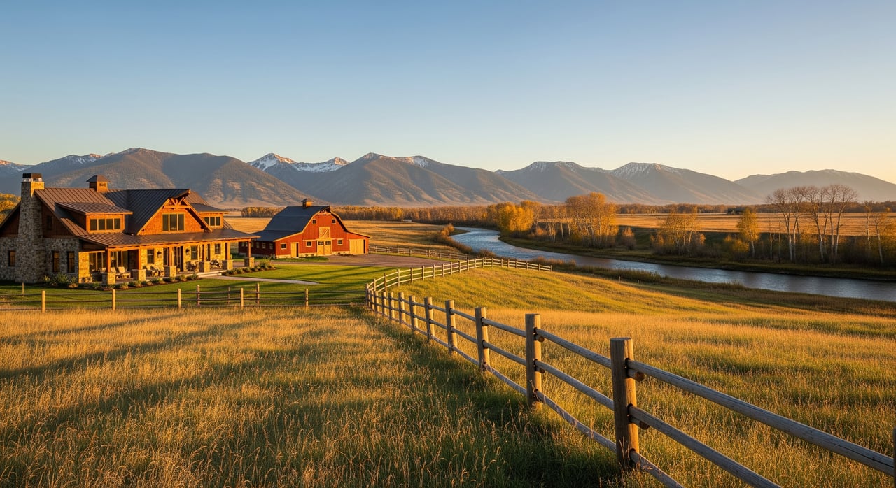
Buyers focus on how much land they can build on, farm, or actively enjoy. Flat, accessible ground usually commands a premium compared to steep slopes, riparian buffers, or heavy wetland coverage. Start by separating total acres from usable acres. A realistic view of usable acres helps you set a price that aligns with how buyers think.
Water and water rights
In Montana, water rights carry real value. Parcels with verified irrigation or domestic water rights often sell for more than similar dryland tracts. River frontage or live water access can also boost appeal, but the legal status of rights under Montana’s prior appropriation system is key. Always verify the type, priority date, and transferability before counting water in your price.
Topography, soils, and drainage
Topography shapes both buildability and cost. Flatter ground reduces site prep and opens more options for homes or barns. Soil type affects septic feasibility and agricultural productivity. Pull soil maps and consider a septic review so you are pricing the land that can truly be developed.
Access, roads, and utilities
Public paved access is a plus. Private driveway easements and gravel roads can be fine, but buyers will weigh maintenance responsibility and year-round access. Power nearby is a value add; running new lines, extending fiber, or drilling a new well adds cost that can reduce what buyers are willing to pay. Natural gas is rare in rural parts of Gallatin County, so plan for alternatives.
Views, privacy, and setting
Wide-angle valley views, mountain vistas, and privacy near the three rivers often add to price. These are subjective factors, yet they consistently influence final offers. Parcels screened from neighbors or road noise tend to draw more interest among lifestyle buyers.
Floodplain, wetlands, and wildfire risk
River proximity can be a selling point, but floodplain or wetland designations limit development and may raise insurance costs. Wildfire risk is another consideration for rural tracts; defensible-space needs and insurance availability can influence buyer decisions. Confirm these items early so you can price with confidence.
Legal and title factors to verify
Zoning and jurisdiction
Whether the parcel is inside the City of Three Forks or in unincorporated Gallatin County will change permitted uses, density, and the path to approvals. Minimum lot sizes, subdivision rules, and clustering options all affect development potential and value. Check the correct jurisdiction before you assume what you can build.
Easements and access
Recorded access easements, utility rights-of-way, and road maintenance agreements matter. Clear, legal access supports stronger pricing because it reduces uncertainty. Unresolved access or shared road disputes often suppress price and increase time on market.
Mineral rights and leases
In Montana, mineral rights can be severed from the surface. If minerals are not included, or if there are surface-use provisions, buyers may discount the property for risk. The same goes for active leases, such as agricultural or hunting, which may affect occupancy and income assumptions.
Conservation easements and covenants
Conservation easements and restrictive covenants limit future uses. Some buyers seek conserved land for lifestyle or tax reasons, but in general, reduced highest-and-best use means lower market value. Price accordingly and disclose clearly.
Property tax classification
Land classification affects property taxes. Agricultural-use classification can reduce tax burden if use tests are met. Confirm current classification and any eligibility for agricultural valuation before you market a price point.
Pricing methods that work here
Sales comparison approach
This is the go-to method for most rural land in Gallatin County. Match recent sales to your parcel based on size, location, usable acres, water rights, access, utilities, and development potential. Make adjustments where your property is better or worse than each comp, then derive a per-usable-acre range.
Income approach
When a parcel produces income, such as irrigated ag leases or timber harvests, capitalize the income to estimate value. This approach is helpful if the buyer pool is investor-oriented or if income is the primary driver of demand.
Hybrid approach
For mixed-use properties, use sales comparison for the land baseline and layer in income analysis for the leased or irrigated components. The goal is to reconcile what market buyers pay with what the income stream supports.
When to get an appraisal
Consider a licensed rural land appraiser when water or mineral rights are complex, subdivision plans are on the table, values are high, there are few comps, or a lender requires it. An appraisal can validate your pricing strategy and help you defend value during negotiations.
A step-by-step pricing workflow
1) Gather base data
Pull parcel boundaries, acreage, legal description, and APN. Confirm title status, mineral rights, easements, current taxes, and any encumbrances. Note utility availability, road type and maintenance, improvements, and well or septic details. Map floodplain, wetlands, topography, and soils, and compile water-right records and any irrigation history.
2) Determine usable acres
Subtract steep slopes, wetlands, riparian setbacks, and other non-developable areas. What remains is your usable or developable acreage. Buyers pay for usability, so this number anchors your valuation.
3) Identify highest and best use
Is the most likely use a single-family rural residence, irrigated ag, recreational retreat, small subdivision, or conservation? Check zoning and subdivision rules to confirm feasibility. Your pricing should reflect the most probable and permitted use.
4) Collect comparable sales
Search recent sales of similar acreage in the Three Forks and greater Gallatin Valley area. Focus on comps with similar usable acres, water rights, access, and utility situations. Include city-versus-county context when relevant.
5) Adjust comparables
Apply adjustments for water rights scope, frontage and access, utility availability, topography and views, development potential, and encumbrances. Track each adjustment so you can explain your rationale to buyers and appraisers.
6) Consider market conditions
Weigh buyer activity, days on market, interest rates, and local employment trends. Seasonality can affect rural land showings and closings. If demand is softening, consider a tighter range or quicker price review cadence.
7) Price using your approach
For sales comparison, derive a per-usable-acre baseline from adjusted comps and build a value range. For income-producing land, run an income approach to check for alignment. Reconcile to a number that fits current market momentum.
8) Set a final strategy
Present a listing price range and a go-to-market number that fits your timing goals. Decide on a negotiation buffer based on your risk tolerance and expected buyer pool. Plan a review date for feedback after the first wave of showings.
Quick checklist: what to pull before you price
- Parcel map, boundaries, legal description, and APN
- Title report with mineral-rights status and all recorded easements
- Water-right records and any irrigation district or historical use notes
- Septic and well status, permits, and any percolation or well logs
- Floodplain and wetlands mapping, plus topography and soils
- Utility availability and road access details with maintenance responsibility
- Recent comparable sales and a worksheet with adjustments and per-usable-acre figures
- Zoning, subdivision rules, and allowed uses by jurisdiction
Red flags that change the price
- Historically irrigated land with no recorded or transferable water rights
- Severed mineral rights or surface-use provisions that limit future enjoyment
- No legal access or unresolved easement issues
- Significant floodplain or wetland coverage limiting buildability
- Septic or well infeasibility on the primary building site
- Restrictive covenants or conservation easements that limit higher-value uses
- High wildfire hazard without feasible mitigation or insurance challenges
- Back taxes, liens, or title defects that complicate closing
Cost and timeline considerations
Extending power, building a driveway, drilling a well, or designing a septic adds cost that buyers factor into offers. If your parcel needs several improvements, expect a wider negotiation range or a longer runway to find the right buyer. Rural land can take longer to sell than in-town residential, so build a timeline that matches your goals and seasonal showing patterns.
Three Forks specifics to confirm
- Jurisdiction: Verify whether the parcel sits inside the City of Three Forks or in unincorporated Gallatin County. This drives zoning, density, and approvals.
- Zoning and subdivision: Confirm minimum lot sizes, required infrastructure, and subdivision review steps with the correct planning department.
- Water rights: Check records for priority dates, flow rates, points of diversion, and whether rights convey with the land.
- Septic and wells: Confirm site suitability, permit history, and any required testing with the local health department.
- Floodplain and wetlands: Review applicable maps to understand restrictions and permit needs before marketing river or riparian features.
- Property tax classification: Verify current classification and any agricultural-use qualifications with the county assessor.
How we help you price with confidence
Acreage pricing in Three Forks is attribute-driven. The most successful sellers lead with verified facts, not assumptions. Our team pairs local knowledge of Gallatin County land with a disciplined pricing workflow. We compile usable-acre calculations, water-right records, access and utility details, and a comp set that tells a clear story. Then we market the land to the right buyer segments with professional positioning that protects your value. Ready to talk strategy or request a pricing review? Reach out to Chelsea Stewart today.
FAQs
How do I calculate usable acres in Three Forks?
- Map steep slopes, wetlands, riparian buffers, and other constrained areas, subtract them from total acreage, and use the remainder as your usable or developable acres.
Why do irrigation rights raise land value in Gallatin County?
- Verified irrigation rights increase productive potential and buyer confidence under Montana’s prior appropriation law, so parcels with transferable rights usually command higher prices.
Can I subdivide my acreage near Three Forks?
- It depends on jurisdiction, zoning, minimum lot sizes, and subdivision regulations, so confirm the parcel’s location and speak with the appropriate planning department before relying on any plan.
How do private road agreements affect value?
- Clear, recorded access and shared maintenance terms support stronger pricing, while unclear or disputed access often reduces buyer interest and sale price.
How long does it take to sell rural acreage around Three Forks?
- Rural land often takes longer than in-town residential due to a more specialized buyer pool and seasonal showing patterns, so plan a longer marketing runway.
Do I need a survey or appraisal before listing acreage?
- A boundary survey and a rural land appraisal are recommended for complex parcels, high-value tracts, or when water, access, or development factors are hard to verify.